
Gilchrist Promontory Fort
2018 Data Structure Report.
The Gilchrist fort is a rather unusual monument and walking past it gives no clue to its existence, size or age. Canmore describes it as a promontory fort based on their interpretation of crop marks as the arcs of three concentric ditches “Apparently designed to cut off approach to a tongue of low-lying and comparatively level ground running NW into marshland, they are in effect part of the defensive system of a promontory fort measuring about 85 m by 30 m”. In addition to the black-and-white photographs on the Canmore database, the late Jim bone, who was an enthusiastic archaeologist and also a pilot, took some good colour photographs of the site. Jim’s aerial photograph shows three dark green curved features representing the fort’s ditches on the east side of the promontory. The ditches are now under cultivation and have been filled in and ploughed flat so there is nothing to see above ground; it is only the aerial photographs that have encouraged archaeologists to see this as a fortified promontory. It is unusual to find a promontory fort inland unless it is in a situation like this where it is surrounded by water or marshland. Most hill and promontory forts in Scotland appear to have been constructed during the late Bronze Age and Iron Age and the latest ones were built or reoccupied in Pictish times.

Our research agenda sought to identify and characterise the ditches, and to ascertain when the fort was constructed, how long it was occupied and what activities may have taken place there. Three large trenches were initially opened, one running at right angles across the defensive ditches, a second running from the long side of the fort down into the bog and a third on the highest part of the interior of the fort. We were very quickly able to establish that the three ditches seen on aerial photographs did exist, with a hint of a fourth ditch closer into the fort. The outermost ditch was reasonably shallow but the second ditch was a massive construction 5-6 m wide at the top and sloping steeply to about 1.5 m below the plough soil though we consider that the upper part of the ditches have been lost due to ploughing and the intervening banks of excavated material flattened. The third innermost ditch was not quite so deep, but right on the edge of the actual fort area we found what may be an inner ditch that might have continued round the fort perimeter as a wall and perhaps with a timber fence palisade on top or just in front.
We were impressed by the scale of these defences, and what we thought was probably a fairly insignificant fort turned out to be a major construction that would have involved a huge amount of labour. It is easy to see these forts simply as defensive structures, but they can also be viewed as symbols of power for the local elite who could assemble their followers during times of unrest or use the fort interior as a place of assembly for civil gatherings and ritual activities. Medieval pottery in the ditch fills showed that the ditches were probably intentionally filled in 500 to 1000 or more years after the fort went out of use. The bigger ditches were filled in with large boulders collected off the fields, probably during a period when Gilchrist farm and community were improving the land for cultivation.
A trench (Trench 7) which we dug running from the interior of the site northwards across the long side of the promontory into the bog, proved to be particularly interesting. Because of the dry summer in 2018 we were able to cut the trench into the bog. However it subsequently filled up with water, showing that the bog still retains a huge amount of moisture. As we excavated down the trench towards the bog we encountered the remains of what could have been a wall running along the side of the promontory. Beyond this point the ground dropped away very steeply. We found pieces of timber which could be the remains of trees but were possibly part of structures such as a palisade fence associated with the fort. However, what was exciting was to find trapped within the remains of the supposed perimeter wall some pieces of pottery and part of a rotary quern. It would appear that these represent rubbish thrown over the side of the fort towards the marsh. The pottery is fragmentary but very thick and quite crudely made by hand. We are currently waiting have this pottery analysed but it may give us a good indicator of the date of use of the fort. Our trench on the highest part of the fort (Trench 2), meanwhile, showed furrows at the base of the topsoil representing old plough marks. It is likely that ploughing activity on top of the fort has destroyed any evidence there, and much of the soil has then drifted downhill.
We opened a fourth trench (Trench 9) further to the west, but still within the fort perimeter. Here one of the aerial photographs suggested that there was a change in soil conditions. This was indeed the case as just under the topsoil we found a spread of clay, too regular and straight sided to be a natural deposit. Although we are still interpreting this evidence, the suggestion is that it may be a floor of a building within the fort which has survived as it is further down the promontory and away from the more intensively ploughed areas. Right on the clay floor we found a small piece of pottery which may be part of a crucible, suggesting small-scale metalworking was being carried out on the site.
There is much post excavation analysis to be done, but the very least we can say at present is that somebody important was living at Gilchrist around two to three thousand years ago who had sufficient power to encourage his (or her) followers to construct what we now know to be a significant defensive feature.
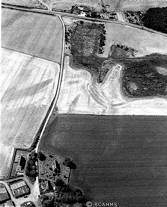
Above: Gilchrist, oblique aerial view, taken from the E, centred on the cropmarks of a promontory fort. Gilchrist Church is visible in the bottom left-hand corner of the photograph (RCAHMS).


Above: Artist's impressions of the fort by Pat Haynes. Below: 3D models of excavation trenches.

Above and Below: Aerial quadcopter views by Andy Hickie - Summer 2018.

See also the Photo Gallery and Video Blog Post.
