
Tarradale Through Time Blog
2018 Excavations: Gilchrist and Balvattie
by Eric Grant - 11:32 on 12 March 2019
In September 2018 two sites were investigated by TARRADALE THROUGH TIME, a fortified enclosure just west of Gilchrist church and a rather enigmatic and possibly ritual site south of Gilchrist church, but located on Balvattie Farm.
Gilchrist Promontory Fort
 The Gilchrist fort is a rather unusual monument and walking past it gives no clue to its existence, size or age. Canmore describes it as a promontory fort based on their interpretation of crop marks as the arcs of three concentric ditches “Apparently designed to cut off approach to a tongue of low-lying and comparatively level ground running NW into marshland, they are in effect part of the defensive system of a promontory fort measuring about 85 m by 30 m”. In addition to the black-and-white photographs on the Canmore database, the late Jim bone, who was an enthusiastic archaeologist and also a pilot, took some good colour photographs of the site. Jim’s aerial photograph shows three dark green curved features representing the fort’s ditches on the east side of the promontory. The ditches are now under cultivation and have been filled in and ploughed flat so there is nothing to see above ground; it is only the aerial photographs that have encouraged archaeologists to see this as a fortified promontory. It is unusual to find a promontory fort inland unless it is in a situation like this where it is surrounded by water or marshland. Most hill and promontory forts in Scotland appear to have been constructed during the late Bronze Age and Iron Age and the latest ones were built or reoccupied in Pictish times.

Our research agenda sought to identify and characterise the ditches, and to ascertain when the fort was constructed, how long it was occupied and what activities may have taken place there. Three large trenches were initially opened, one running at right angles across the defensive ditches, a second running from the long side of the fort down into the bog and a third on the highest part of the interior of the fort. We were very quickly able to establish that the three ditches seen on aerial photographs did exist, with a hint of a fourth ditch closer into the fort. The outermost ditch was reasonably shallow but the second ditch was a massive construction 5-6 m wide at the top and sloping steeply to about 1.5 m below the plough soil though we consider that the upper part of the ditches have been lost due to ploughing and the intervening banks of excavated material flattened. The third innermost ditch was not quite so deep, but right on the edge of the actual fort area we found what may be an inner ditch that might have continued round the fort perimeter as a wall and perhaps with a timber fence palisade on top or just in front.
 We were impressed by the scale of these defences, and what we thought was probably a fairly insignificant fort turned out to be a major construction that would have involved a huge amount of labour. It is easy to see these forts simply as defensive structures, but they can also be viewed as symbols of power for the local elite who could assemble their followers during times of unrest or use the fort interior as a place of assembly for civil gatherings and ritual activities. Medieval pottery in the ditch fills showed that the ditches were probably intentionally filled in 500 to 1000 or more years after the fort went out of use. The bigger ditches were filled in with large boulders collected off the fields, probably during a period when Gilchrist farm and community were improving the land for cultivation.
 A trench (Trench 7) which we dug running from the interior of the site northwards across the long side of the promontory into the bog, proved to be particularly interesting. Because of the dry summer in 2018 we were able to cut the trench into the bog. However it subsequently filled up with water, showing that the bog still retains a huge amount of moisture. As we excavated down the trench towards the bog we encountered the remains of what could have been a wall running along the side of the promontory. Beyond this point the ground dropped away very steeply. We found pieces of timber which could be the remains of trees but were possibly part of structures such as a palisade fence associated with the fort. However, what was exciting was to find trapped within the remains of the supposed perimeter wall some pieces of pottery and part of a rotary quern. It would appear that these represent rubbish thrown over the side of the fort towards the marsh. The pottery is fragmentary but very thick and quite crudely made by hand. We are currently waiting have this pottery analysed but it may give us a good indicator of the date of use of the fort. Our trench on the highest part of the fort (Trench 2), meanwhile, showed furrows at the base of the topsoil representing old plough marks. It is likely that ploughing activity on top of the fort has destroyed any evidence there, and much of the soil has then drifted downhill.
We opened a fourth trench (Trench 9)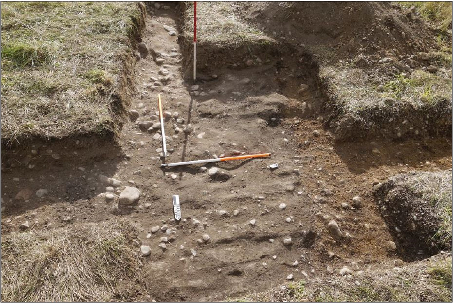 further to the west, but still within the fort perimeter. Here one of the aerial photographs suggested that there was a change in soil conditions. This was indeed the case as just under the topsoil we found a spread of clay, too regular and straight sided to be a natural deposit. Although we are still interpreting this evidence, the suggestion is that it may be a floor of a building within the fort which has survived as it is further down the promontory and away from the more intensively ploughed areas. Right on the clay floor we found a small piece of pottery which may be part of a crucible, suggesting small-scale metalworking was being carried out on the site.
There is much post excavation analysis to be done, but the very least we can say at present is that somebody important was living at Gilchrist around two to three thousand years ago who had sufficient power to encourage his (or her) followers to construct what we now know to be a significant defensive feature.

Artist's impression of how the fort may have looked by Pat Haynes

The second site excavated in 2018, lying about 350 m south-east of Gilchrist church but on Balvattie Farm, was very different. It was also discovered from aerial photographs which show a circular feature in a cultivated field. There are also arc-shaped features further out as well as some linear patterns. The circular feature superficially looks like a roundhouse, but at 26 to 30 m in diameter it seems far too large. The Canmore website simply describes these features as an enclosure of unassigned period. Our excavations showed that the site is a large and complex one, and likely to date from the prehistoric period.
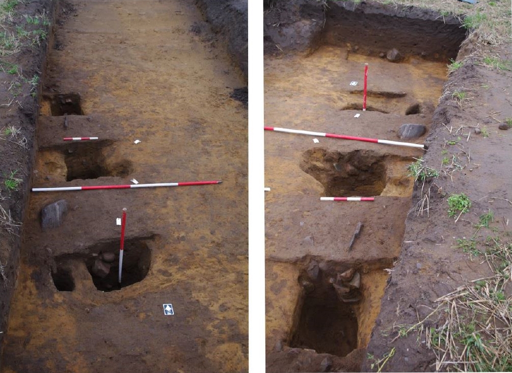
 Trench 3 picked up the circular feature nicely, revealing a ditch about 2 m wide and up to a metre deep, The upper part of the ditch has been destroyed by ploughing, which is why there is no indication of it on the surface. There was much evidence of intensive burning within the area enclosed by the circular ditch, but apart from a few pieces of charcoal and some tiny pieces of bone there was no indication of what the burning had been for. Outside the ditched enclosure were a number of pits about a metre wide and half a metre deep (but originally probably twice as deep). These pits may initially have had large posts with stones packed round the base, but it appears that they are not simple post holes as small pieces of pottery were carefully deposited in these pits. Similar pits dating from about 5000 years ago have been found in southern England. However, until scientific results are obtained we are unable to say how old these pits are and what their function was.
We also excavated a very large pit that stood out as a prominent lush mark on aerial photographs (Trench 4). Dumped field gathered stones and much evidence of burning filled the higher levels of the pit but the original pit, 2 m deep, may have been a naturally formed hole that filled up with slope-washed coarse sand and gravel and was levelled off much later.
 Trench 6 picked up one of the curved ditches seen on aerial photographs. This was a well-constructed, narrow and straight-sided ditch, ending with a distinct terminal feature and a post hole adjacent to it. A tentative interpretation is that it may have been a ditch or slot for a wooden palisade with a gap for an entrance or gateway and an additional post for strength. The linear features seen on aerial photographs may represent paths running through the entrance way to the inner circular enclosure where some activity was being carried out that required intense burning. These features may not all be the same age, but they are likely to be Neolithic or Bronze Age. There is no suggestion that the site at Balvattie was defensive in the way that the fort at Gilchrist appears to have been, but the Balvattie site again represents a huge amount of labour input suggesting a complex social order was in control.
Over the last two years, Tarradale Through Time’s excavations have uncovered significant archaeological remains, pointing to multiperiod exploitation of the land over several thousand years, and sometimes raising more questions than answers. What has been discovered so far suggests that the wider Muir of Ord area was extremely important in the past and of increasing significance in relation to what we know about the archaeology of the Highlands.
This post was first published on the NOSAS Blog - see https://nosasblog.wordpress.com/2019/03/11/tarradale-through-time-2018-excavations/
Add your comment
